|
|
Antenna Structure Registration 1041442 |
 |
Registration Info | Registration Number: 1041442 |
| File Number: A1121878 |
| FAA Study: 2018-AGL-18288-OE |
| FAA Issue Date: 11/30/2018 |
| Status: Constructed |
| Date Constructed: 05/01/1977 |
| NEPA: N |
Structure Info
| Structure Type: GTOWER |
| Structure Coordinates: 45-54-9.9 N 92-57-33.9 W (NAD 83) |
| Structure Coordinates: 45-54-10.1 N 92-57-33.2 W (Converted to NAD 27) |
| Structure Address: State Highway 14 At Highway 61 |
| Structure City: Pine City, MN |
| Structure County: Pine County |
| Painting & Lighting Info |
FCC Paragraph(s): 1, 3, 11, 21 |
Remarks: Continue As Is OM&L = PAINT/RED LIGHTS |
Remarks: PRIOR STUDY 2000-AGL-8650-OE |
Remarks: Continue As Is OM&L = PAINT/RED LIGHTS |
Remarks: PRIOR STUDY 2000-AGL-8650-OE |
| Elevation Info |
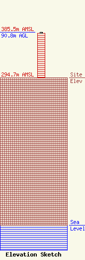
Site Elevation: 294.7 meters (967 ft) |
| Height of Structure: 89 meters (292 feet) |
| Overall Height Above Ground: 90.8 meters (298 feet) |
| Overall Height Above Mean Sea Level: 385.5 meters (1265 feet) |
| Owner Info | Q MEDIA PROPERTIES, LLC
474 GUERNSEY LANE
RED WING, MN 55066
(651) 388-7151
ARK9970@AOL.COM |
| Contact Info | SHAINIS & PELTZMAN, CHARTERED
1850 M STREET
WASHINGTON, DC 20036
LEE PELTZMAN
(202) 293-0011
LEE@S-PLAW.COM |
