|
|
Antenna Structure Registration 1041653 |
 |
Registration Info | Registration Number: 1041653 |
| File Number: A1197954 |
| FAA Study: 88-AGL-1075-OE |
| FAA Issue Date: 09/12/1988 |
| Status: Constructed |
| Date Constructed: 03/29/1989 |
| FAA EMI: N |
| NEPA: N |
Structure Info
|
| Structure Coordinates: 44-55-15.0 N 96-53-34.0 W (NAD 83) |
| Structure Coordinates: 44-55-15.1 N 96-53-32.8 W (Converted to NAD 27) |
| Structure Address: One Mi E 2.5 Mi N |
| Structure City: Kranzburg, SD |
| Structure County: Codington County |
| Painting & Lighting Info |
FAA Circular #: 70/7460-1G |
FAA Chapters: 3, 4, 5, 9 |
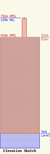
| Elevation Info |
Site Elevation: 616 meters (2021 ft) |
| Height of Structure: 123 meters (404 feet) |
| Overall Height Above Ground: 125 meters (410 feet) |
| Overall Height Above Mean Sea Level: 741 meters (2431 feet) |
| Owner Info | TowerCo 2013 LLC
5000 Valleystone Drive, Suite 200
Cary, NC 27519
(919) 653-5700
cdoherty@towerco.com |
| Contact Info | TowerCo 2013 LLC
5000 Valleystone Drive, Suite 200
Cary, NC 27519
Chad Doherty
(919) 653-5700
cdoherty@towerco.com |
