|
|
Antenna Structure Registration 1042149 |
 |
Registration Info | Registration Number: 1042149 |
| File Number: A0049690 |
| FAA Study: 90-AGL-1447-OE |
| FAA Issue Date: 11/21/1990 |
| Status: Constructed |
| Date Constructed: 01/01/1991 |
| NEPA: N |
Structure Info
| Structure Type: TOWER |
| Structure Coordinates: 44-11-39.0 N 98-19-5.0 W (NAD 83) |
| Structure Coordinates: 44-11-39.0 N 98-19-03.7 W (Converted to NAD 27) |
| Structure Address: Ne 1/4 Se6 Warren Township Canborn Ct Sd |
| Structure City: Alpena, SD |
| Structure County: Sanborn County |
| Painting & Lighting Info |
FCC Paragraph(s): A1, B, D, H |
Remarks: HIGH INTENSITY WHITE LIGHTS/RED. |
| Elevation Info |
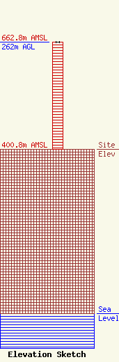
Site Elevation: 400.8 meters (1315 ft) |
| Height of Structure: 262 meters (860 feet) |
| Overall Height Above Ground: 262 meters (860 feet) |
| Overall Height Above Mean Sea Level: 662.8 meters (2175 feet) |
| Owner Info | RIBOB & ELJIM A SD PARTNERSHIP
2901 W 11TH ST
SIOUX FALLS, SD 57104
(605) 338-0017
|
