|
|
Antenna Structure Registration 1042157 |
 |
Registration Info | Registration Number: 1042157 |
| File Number: A0909946 |
| FAA Study: 98-AGL-1156-OE |
| FAA Issue Date: 04/22/1998 |
| Status: Constructed |
| Date Constructed: 01/01/1978 |
| FAA EMI: N |
| NEPA: N |
Structure Info
| Structure Type: 2TA2 |
| Structure Coordinates: 44-3-42.0 N 103-10-36.0 W (NAD 83) |
| Structure Coordinates: 44-03-42.0 N 103-10-34.4 W (Converted to NAD 27) |
| Structure Address: Twr 2 - 1.3 Km Se Of City Limits |
| Structure City: Rapid City, SD |
| Structure County: Pennington County |
| Painting & Lighting Info |
FCC Paragraph(s): 1, 3, 11, 21 |
Remarks: RED LIGHTS/PAINT. |
| Elevation Info |
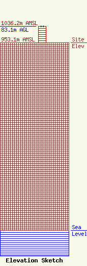
Site Elevation: 953.1 meters (3127 ft) |
| Height of Structure: 82.2 meters (270 feet) |
| Overall Height Above Ground: 83.1 meters (273 feet) |
| Overall Height Above Mean Sea Level: 1036.2 meters (3400 feet) |
| Owner Info | HOMESLICE MEDIA GROUP, LLC
1612 JUNCTION AVENUE
STURGIS, SD 57785
(605) 347-5336
DEAN@THEHOMESLICEGROUP.COM |
| Contact Info | SCIARRINO & SHUBERT, PLLC
5425 TREE LINE DRIVE
CENTREVILLE, VA 20120
DAWN SCIARRINO
(202) 350-9658
DAWN@SCIARRINOLAW.COM |
