|
|
Antenna Structure Registration 1042159 |
 |
Registration Info | Registration Number: 1042159 |
| File Number: A1253595 |
| FAA Study: 2023-AGL-15261-OE |
| FAA Issue Date: 08/25/2023 |
| Status: Constructed |
| Date Constructed: 09/14/2023 |
| NEPA: N |
Structure Info
| Structure Type: GTOWER |
| Structure Coordinates: 44-2-48.9 N 103-14-46.6 W (NAD 83) |
| Structure Coordinates: 44-02-48.9 N 103-14-44.9 W (Converted to NAD 27) |
| Structure Address: W Of Tower Rd & Skyline Dr Jct |
| Structure City: Rapid City, SD |
| Structure County: Pennington County |
| Painting & Lighting Info |
FAA Circular #: 70/7460-1M |
FAA Chapters: 4, 8, 15 |
Remarks: PRIOR STUDY 1998-AGL-1155-OE |
| Elevation Info |
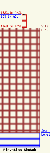
Site Elevation: 1169.5 meters (3837 ft) |
| Height of Structure: 152.6 meters (501 feet) |
| Overall Height Above Ground: 153.6 meters (504 feet) |
| Overall Height Above Mean Sea Level: 1323.1 meters (4341 feet) |
| Owner Info | HomeSlice Media Group, LLC
1612 Junction Avenue
Sturgis, SD 57785
(605) 347-5336
dean.kinney@thehomeslicegroup.com |
| Contact Info | HomeSlice Media Group, LLC
1612 Junction Avenue
Sturgis, SD 57785
Christopher Jaques
(605) 347-5336
chris.jaques@thehomeslicegroup.com |
