|
|
Antenna Structure Registration 1042293 |
 |
Registration Info | Registration Number: 1042293 |
| File Number: A1197476 |
| FAA Study: 2021-ANE-368-OE |
| FAA Issue Date: 02/05/2021 |
| Status: Constructed |
| Date Constructed: 02/16/2021 |
Structure Info
| Structure Type: GTOWER |
| Structure Coordinates: 44-29-47.1 N 73-12-47.5 W (NAD 83) |
| Structure Coordinates: 44-29-46.9 N 73-12-49.0 W (Converted to NAD 27) |
| Structure Address: Twr 2 Intervale Rd |
| Structure City: Burlington, VT |
| Structure County: Chittenden County |
| Painting & Lighting Info |
FAA Circular #: 70/7460-1K |
FAA Chapters: 3, 4, 5, 12 |
Remarks: PRIOR STUDY 2013-ANE-529-OE |
Remarks: OM&L to remain the same as prior study = PAINT/RED LIGHTS |
Remarks: PRIOR STUDY 2013-ANE-529-OE |
Remarks: OM&L to remain the same as prior study = PAINT/RED LIGHTS |
| Elevation Info |
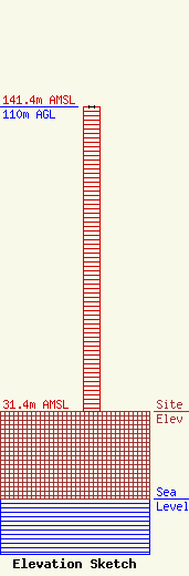
Site Elevation: 31.4 meters (103 ft) |
| Height of Structure: 110 meters (361 feet) |
| Overall Height Above Ground: 110 meters (361 feet) |
| Overall Height Above Mean Sea Level: 141.4 meters (464 feet) |
| Owner Info | Independent Digital & Wireless, Inc.
288 South River Road
Bedford, NH 03110
(603) 668-9999
lisab@nebcast.com |
| Contact Info | Independent Digital & Wireless, Inc.
288 South River Road
Bedford, NH 03110
Lisa Burgess
(603) 668-9999
lisab@nebcast.com |
