|
|
Antenna Structure Registration 1042326 |
 |
Registration Info | Registration Number: 1042326 |
| File Number: A1164413 |
| FAA Study: 2018-ASO-16362-OE |
| FAA Issue Date: 04/09/2019 |
| Status: Constructed |
| Date Constructed: 01/01/1980 |
| NEPA: N |
Structure Info
| Structure Type: GTOWER |
| Structure Coordinates: 33-39-27.0 N 90-42-17.2 W (NAD 83) |
| Structure Coordinates: 33-39-26.6 N 90-42-16.9 W (Converted to NAD 27) |
| Structure Address: 4.9 Mi 170 Sse / Us-ms-5038 |
| Structure City: Cleveland, MS |
| Structure County: Bolivar County |
| Painting & Lighting Info |
FCC Paragraph(s): A1, B, D, H |
Remarks: Continue As Is OM&L = 24-HR HI-STROBES |
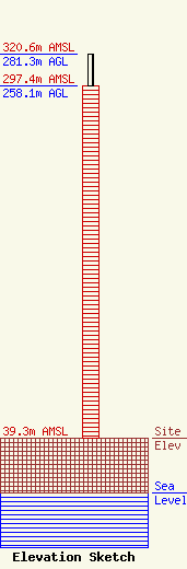
| Elevation Info |
Site Elevation: 39.3 meters (129 ft) |
| Height of Structure: 258.1 meters (847 feet) |
| Overall Height Above Ground: 281.3 meters (923 feet) |
| Overall Height Above Mean Sea Level: 320.6 meters (1052 feet) |
| Owner Info | Vertical Bridge Towers III, LLC
750 Park of Commerce Dr.
Boca Raton, FL 33487
(561) 406-4015
FCC-FAA@verticalbridge.com |
| Contact Info | Vertical Bridge Towers III, LLC
750 Park of Commerce Dr.
Boca Raton, FL 33487
Richard Hickey
(561) 406-4015
FCC-FAA@verticalbridge.com |
