|
|
Antenna Structure Registration 1042438 |
 |
Registration Info | Registration Number: 1042438 |
| File Number: A1168977 |
| FAA Study: 83-ASO-1845-OE |
| Status: Dismantled |
| Date Constructed: 01/10/1984 |
| FAA EMI: N |
| NEPA: N |
Structure Info
|
| Structure Coordinates: 25-1-36.0 N 80-30-29.0 W (NAD 83) |
| Structure Coordinates: 25-01-34.5 N 80-30-29.8 W (Converted to NAD 27) |
| Structure Address: 93351 Overseas Highway |
| Structure City: Tavernier, FL |
| Structure County: Monroe County |
| Painting & Lighting Info |
FAA Circular #: 70/7460-1F |
FAA Chapters: 3, 4, 5, 9 |
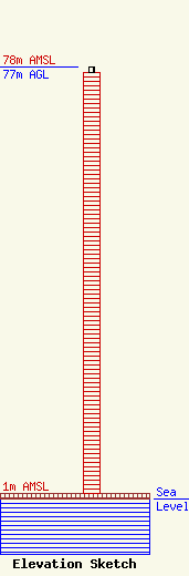
| Elevation Info |
Site Elevation: 1 meters (3 ft) |
| Height of Structure: 76 meters (249 feet) |
| Overall Height Above Ground: 77 meters (253 feet) |
| Overall Height Above Mean Sea Level: 78 meters (256 feet) |
| Owner Info | Vertical Bridge CC FM, LLC
750 Park of Commerce Dr.
Boca Raton, FL 33487
(561) 406-4015
fcc-faa@verticalbridge.com |
| Contact Info | Vertical Bridge CC FM, LLC
750 Park of Commerce Dr.
Boca Raton, FL 33487
Richard Hickey
(561) 406-4015
fcc-faa@verticalbridge.com |
