|
|
Antenna Structure Registration 1042618 |
 |
Registration Info | Registration Number: 1042618 |
| File Number: A1341994 |
| FAA Study: 2015-ACE-3519-OE |
| FAA Issue Date: 07/19/2016 |
| Status: Constructed |
| Date Constructed: 11/01/1998 |
| NEPA: N |
Structure Info
| Structure Type: GTOWER |
| Structure Coordinates: 38-45-1.0 N 92-33-32.0 W (NAD 83) |
| Structure Coordinates: 38-45-00.9 N 92-33-31.3 W (Converted to NAD 27) |
| Structure Address: 0.7 Km W Of D Hwy 7.5 Km Sse |
| Structure City: Prarie Home, MO |
| Structure County: Moniteau County |
| Painting & Lighting Info |
FAA Circular #: 70/7460-1L |
FAA Chapters: 3, 4, 5, 12 |
Remarks: PRIOR STUDY 1998-ACE-54-OE |
| Elevation Info |
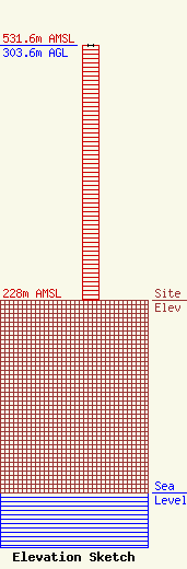
Site Elevation: 228 meters (748 ft) |
| Height of Structure: 302.7 meters (993 feet) |
| Overall Height Above Ground: 303.6 meters (996 feet) |
| Overall Height Above Mean Sea Level: 531.6 meters (1744 feet) |
| Owner Info | VB Nimbus, LLC
22 W Atlantic Avenue
Delray Beach, FL 33444
(561) 406-4015
fcc-faa@verticalbridge.com |
| Contact Info | VB Nimbus, LLC
22 W Atlantic Avenue
Delray Beach, FL 33444
Richard Hickey
(561) 406-4015
fcc-faa@verticalbridge.com |
