|
|
Antenna Structure Registration 1042983 |
 |
Registration Info | Registration Number: 1042983 |
| File Number: A1204533 |
| FAA Study: 2017-AEA-7682-OE |
| FAA Issue Date: 09/05/2017 |
| Status: Constructed |
| Date Constructed: 05/28/2017 |
| NEPA: N |
Structure Info
| Structure Type: LTOWER |
| Structure Coordinates: 38-57-22.3 N 77-4-57.3 W (NAD 83) |
| Structure Coordinates: 38-57-21.9 N 77-04-58.4 W (Converted to NAD 27) |
| Structure Address: 5151 Wisconsin Ave Nw |
| Structure City: Washington, DC |
| Structure County: District of Columbia |
| Painting & Lighting Info |
FCC Paragraph(s): 1, 3, 5, 14, 21 |
Remarks: Continue As Is OM&L = PAINT/RED LIGHTS |
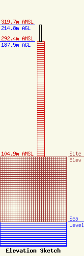
| Elevation Info |
Site Elevation: 104.9 meters (344 ft) |
| Height of Structure: 187.5 meters (615 feet) |
| Overall Height Above Ground: 214.8 meters (705 feet) |
| Overall Height Above Mean Sea Level: 319.7 meters (1049 feet) |
| Owner Info | Harrison Wisconsin Owner, LLC
801 17th Street, N.W. Suite 1000
20006
washington, DC 20006
(202) 452-1400
vmp@gdllaw.com |
| Contact Info | Greenstein DeLorme & Luchs, P.C
801 17th Street, N.W. Suite 1000
20006
washington, DC 20006
Vincent Policy
(202) 452-1400
vmp@gdllaw.com |
