|
|
Antenna Structure Registration 1043132 |
 |
Registration Info | Registration Number: 1043132 |
| File Number: A1297392 |
| FAA Study: 98-ASO-2183-OE |
| FAA Issue Date: 05/06/1998 |
| Status: Constructed |
| Date Constructed: 09/08/1998 |
| FAA EMI: N |
| NEPA: N |
Structure Info
| Structure Type: TOWER |
| Structure Coordinates: 37-15-18.0 N 83-12-3.0 W (NAD 83) |
| Structure Coordinates: 37-15-17.7 N 83-12-03.4 W (Converted to NAD 27) |
| Structure Address: 199 Black Gold Blvd |
| Structure City: Hazard, KY |
| Structure County: Perry County |
| Painting & Lighting Info |
FAA Circular #: 70/7460-1J |
FAA Chapters: 3, 4, 5, 13 |
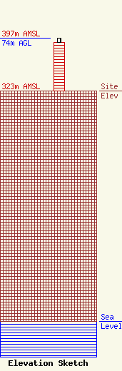
| Elevation Info |
Site Elevation: 323 meters (1060 ft) |
| Height of Structure: 68 meters (223 feet) |
| Overall Height Above Ground: 74 meters (243 feet) |
| Overall Height Above Mean Sea Level: 397 meters (1302 feet) |
| Owner Info | Gray Local Media, Inc.
4370 Peachtree Road, NE
Atlanta, GA 30319
(404) 266-8333
legalnotices@graymedia.com |
| Contact Info | Gray Local Media, Inc.
4370 Peachtree Road NE
Atlanta, GA 30319
Engineering Department
(404) 266-8333
legalnotices@graymedia.com |
