|
|
Antenna Structure Registration 1043247 |
 |
Registration Info | Registration Number: 1043247 |
| File Number: A1289946 |
| FAA Study: 2024-ASO-6417-OE |
| FAA Issue Date: 07/15/2024 |
| Status: Constructed |
| Date Constructed: 07/24/2024 |
| NEPA: N |
Structure Info
| Structure Type: GTOWER |
| Structure Coordinates: 38-3-56.6 N 84-29-13.4 W (NAD 83) |
| Structure Coordinates: 38-03-56.3 N 84-29-13.6 W (Converted to NAD 27) |
| Structure Address: 1065 Russell Cave Road |
| Structure City: Lexington, KY |
| Structure County: Fayette County |
| Painting & Lighting Info |
FAA Circular #: 70/7460-1M |
FAA Chapters: 4, 8, 15 |
| Elevation Info |
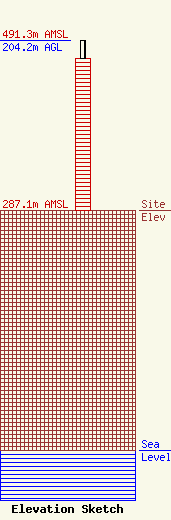
Site Elevation: 287.1 meters (942 ft) |
| Height of Structure: 183.1 meters (601 feet) |
| Overall Height Above Ground: 204.2 meters (670 feet) |
| Overall Height Above Mean Sea Level: 491.3 meters (1612 feet) |
| Owner Info | Scripps Broadcasting Holdings LLC
312 Walnut Street
Cincinnati, OH 45202
(513) 977-3000
dave.giles@scripps.com |
| Contact Info | Cooley LLP
1299 Pennsylvania Ave., NW
Washington, DC 20004
Christina Burrow
(202) 776-2687
cburrow@cooley.com |
