|
|
Antenna Structure Registration 1043565 |
 |
Registration Info | Registration Number: 1043565 |
| File Number: A1240704 |
| FAA Study: 2021-ASO-47968-OE |
| FAA Issue Date: 03/17/2022 |
| Status: Constructed |
| Date Constructed: 03/28/2023 |
| NEPA: N |
Structure Info
| Structure Type: GTOWER |
| Structure Coordinates: 36-21-45.0 N 88-50-57.0 W (NAD 83) |
| Structure Coordinates: 36-21-44.8 N 88-50-56.8 W (Converted to NAD 27) |
| Structure Address: 733 N Lindell St |
| Structure City: Martin, TN |
| Structure County: Weakley County |
| Painting & Lighting Info |
FAA Circular #: 70/7460-1M |
FAA Chapters: 4, 6, 15 |
Remarks: PRIOR STUDY 1988-ASO-2301-OE |
| Elevation Info |
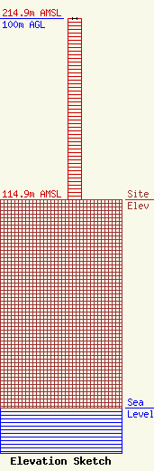
Site Elevation: 114.9 meters (377 ft) |
| Height of Structure: 100 meters (328 feet) |
| Overall Height Above Ground: 100 meters (328 feet) |
| Overall Height Above Mean Sea Level: 214.9 meters (705 feet) |
| Owner Info | Thunderbolt Broadcasting Company
733 N LINDELL ST
318
MARTIN, TN 38237
(731) 587-9526
paultinkle@wcmt.com |
| Contact Info | Thunderbolt Broadcasting Company
733 N LINDELL ST
318
MARTIN, TN 38237
Paul Tinkle
(731) 587-9526
paultinkle@wcmt.com |
