|
|
Antenna Structure Registration 1043911 |
 |
Registration Info | Registration Number: 1043911 |
| File Number: A1262372 |
| FAA Study: 2004-ASO-2009-OE |
| FAA Issue Date: 05/03/2004 |
| Status: Constructed |
| Date Constructed: 08/16/2007 |
| FAA EMI: Y |
| NEPA: N |
Structure Info
| Structure Type: TOWER |
| Structure Coordinates: 35-38-49.1 N 88-50-0.2 W (NAD 83) |
| Structure Coordinates: 35-38-48.8 N 88-49-60.0 W (Converted to NAD 27) |
| Structure Address: 122 Radio Rd |
| Structure City: Jackson, TN |
| Structure County: Madison County |
| Painting & Lighting Info |
FAA Circular #: 70/7460-1K |
FAA Chapters: 3, 4, 5, 12 |
Remarks: PRIOR STUDY 1998-ASO-2390-OE |
| Elevation Info |
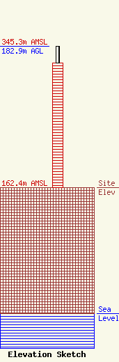
Site Elevation: 162.4 meters (533 ft) |
| Height of Structure: 161.5 meters (530 feet) |
| Overall Height Above Ground: 182.9 meters (600 feet) |
| Overall Height Above Mean Sea Level: 345.3 meters (1133 feet) |
| Owner Info | Forever Communications, Inc.
351 Pascoe Blvd
Bowling Green, KY 42104
(270) 843-3333
chris@forevercom.com |
| Contact Info | Forever Communications, Inc.
351 Pascoe Blvd
Bowling Green, KY 42104
Christine Hillard
(270) 843-3333
chris@forevercom.com |
