|
|
Antenna Structure Registration 1043916 |
 |
Registration Info | Registration Number: 1043916 |
| File Number: A0523934 |
| Status: Constructed |
| Date Constructed: 11/01/1946 |
| FAA EMI: N |
| NEPA: N |
Structure Info
| Structure Type: TOWER |
| Structure Coordinates: 36-45-37.0 N 88-38-20.0 W (NAD 83) |
| Structure Coordinates: 36-45-36.8 N 88-38-19.8 W (Converted to NAD 27) |
| Structure Address: St Rt 1176 Hwy 45n |
| Structure City: Mayfield, KY |
| Structure County: Graves County |
| Painting & Lighting Info |
FCC Paragraph(s): 1, 3, 12, 21 |
| Elevation Info |
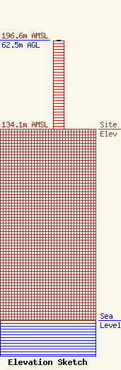
Site Elevation: 134.1 meters (440 ft) |
| Height of Structure: 62.2 meters (204 feet) |
| Overall Height Above Ground: 62.5 meters (205 feet) |
| Overall Height Above Mean Sea Level: 196.6 meters (645 feet) |
| Owner Info | Bristol Broadcasting Company, Inc.
P. O. Box 1389
Bristol, VA 24203
(276) 669-8112
roger@wxbq.com |
