|
|
Antenna Structure Registration 1044036 |
 |
Registration Info | Registration Number: 1044036 |
| File Number: A0051792 |
| FAA Study: CLE-OE-66-237 |
| FAA Issue Date: 08/26/1966 |
| Status: Constructed |
| Date Constructed: 01/01/1968 |
| NEPA: N |
Structure Info
| Structure Type: TOWER |
| Structure Coordinates: 36-41-34.0 N 88-32-11.0 W (NAD 83) |
| Structure Coordinates: 36-41-33.8 N 88-32-10.8 W (Converted to NAD 27) |
| Structure Address: 2.7 Km Nw |
| Structure City: Farmington, KY |
| Structure County: Graves County |
| Painting & Lighting Info |
FCC Paragraph(s): 1, 3, 5, 14, 21 |
Remarks: RED LIGHTS/PAINT |
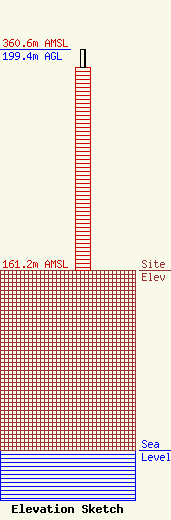
| Elevation Info |
Site Elevation: 161.2 meters (529 ft) |
| Height of Structure: 182.7 meters (599 feet) |
| Overall Height Above Ground: 199.4 meters (654 feet) |
| Overall Height Above Mean Sea Level: 360.6 meters (1183 feet) |
| Owner Info | KENTUCKY AUTHORITY FOR EDUCATIONAL TELEVISION DBA = MKMU
600 COOPER DR
LEXINGTON, KY 40502-2296
(606) 258-7172
STALBERT@KET.ORG |
