|
|
Antenna Structure Registration 1044039 |
 |
Registration Info | Registration Number: 1044039 |
| File Number: A1140765 |
| FAA Study: 2017-ASO-22086-OE |
| FAA Issue Date: 12/18/2017 |
| Status: Constructed |
| Date Constructed: 07/26/2019 |
Structure Info
| Structure Type: LTOWER |
| Structure Coordinates: 39-1-51.0 N 84-30-23.0 W (NAD 83) |
| Structure Coordinates: 39-01-50.8 N 84-30-23.2 W (Converted to NAD 27) |
| Structure Address: E Of Lookaway Dr |
| Structure City: Covington, KY |
| Structure County: Kenton County |
| Painting & Lighting Info |
FAA Circular #: 70/7460-1L |
FAA Chapters: 3, 4, 5, 12 |
Remarks: PRIOR STUDY 1998-ASO-4078-OE |
Remarks: Removed expiration date from determination. Scenario 1./jjs/case#635066 |
Remarks: PRIOR STUDY 1998-ASO-4078-OE |
Remarks: Removed expiration date from determination. Scenario 1./jjs/case#635066 |
| Elevation Info |
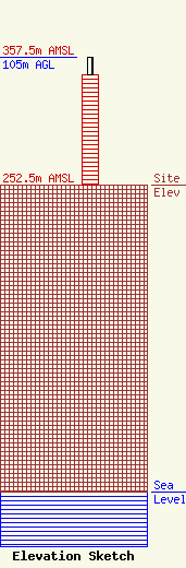
Site Elevation: 252.5 meters (828 ft) |
| Height of Structure: 90.7 meters (298 feet) |
| Overall Height Above Ground: 105 meters (344 feet) |
| Overall Height Above Mean Sea Level: 357.5 meters (1173 feet) |
| Owner Info | KENTUCKY AUTHORITY FOR EDUCATIONAL TELEVISION DBA WCVN
600 COOPER DR
LEXINGTON, KY 40502-2296
(859) 258-7000
SHOPKINS@KET.ORG |
| Contact Info | KENTUCKY AUTHORITY FOR EDUCATIONAL TELEVISION DBA WCVN
600 Cooper Drive
2587000
Lexington, KY 40502
Curtis Harper
(859) 258-7000
charper@ket.org |
