|
|
Antenna Structure Registration 1044040 |
 |
Registration Info | Registration Number: 1044040 |
| File Number: A0051796 |
| FAA Study: 98-ASO-4076-OE |
| FAA Issue Date: 07/29/1998 |
| Status: Constructed |
| Date Constructed: 01/01/1967 |
| NEPA: N |
Structure Info
| Structure Type: TOWER |
| Structure Coordinates: 37-52-45.0 N 84-19-33.0 W (NAD 83) |
| Structure Coordinates: 37-52-44.7 N 84-19-33.2 W (Converted to NAD 27) |
| Structure Address: 1.6 Km Se |
| Structure City: Clays Ferry, KY |
| Structure County: Madison County |
| Painting & Lighting Info |
FCC Paragraph(s): 1, 3, 6, 15, 21 |
Remarks: PREV. 95-ASO-1370-OE. |
| Elevation Info |
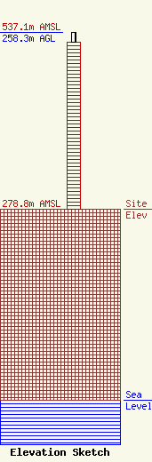
Site Elevation: 278.8 meters (915 ft) |
| Height of Structure: 245.1 meters (804 feet) |
| Overall Height Above Ground: 258.3 meters (847 feet) |
| Overall Height Above Mean Sea Level: 537.1 meters (1762 feet) |
| Owner Info | KENTUCKY AUTHORITY FOR EDUCATIONAL TELEVISION DBA = WKLE
600 COOPER DR
LEXINGTON, KY 40502-2296
(606) 258-7172
STALBERT@KET.ORG |
