|
|
Antenna Structure Registration 1044041 |
 |
Registration Info | Registration Number: 1044041 |
| File Number: A0051797 |
| FAA Study: 98-ASO-4075-OE |
| FAA Issue Date: 07/14/1998 |
| Status: Constructed |
| Date Constructed: 01/01/1968 |
| NEPA: N |
Structure Info
| Structure Type: TOWER |
| Structure Coordinates: 38-10-38.0 N 83-24-17.0 W (NAD 83) |
| Structure Coordinates: 38-10-37.7 N 83-24-17.3 W (Converted to NAD 27) |
| Structure Address: 2.6 Km E Near Usda Lookout |
| Structure City: Morehead, KY |
| Structure County: Rowan County |
| Painting & Lighting Info |
FCC Paragraph(s): 1, 3, 5, 14, 21 |
Remarks: PREV. 66-CLE-0143-OE. |
| Elevation Info |
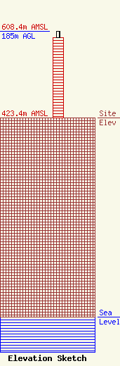
Site Elevation: 423.4 meters (1389 ft) |
| Height of Structure: 170.8 meters (560 feet) |
| Overall Height Above Ground: 185 meters (607 feet) |
| Overall Height Above Mean Sea Level: 608.4 meters (1996 feet) |
| Owner Info | KENTUCKY AUTHORITY FOR EDUCATIONAL TELEVISION DBA = WKMR
600 COOPER DR
LEXINGTON, KY 40502-2296
(606) 258-7172
STALBERT@KET.ORG |
