|
|
Antenna Structure Registration 1044042 |
 |
Registration Info | Registration Number: 1044042 |
| File Number: A1140768 |
| FAA Study: 2017-ASO-22087-OE |
| FAA Issue Date: 11/30/2017 |
| Status: Constructed |
| Date Constructed: 07/26/2019 |
Structure Info
| Structure Type: LTOWER |
| Structure Coordinates: 38-27-44.0 N 82-37-12.0 W (NAD 83) |
| Structure Coordinates: 38-27-43.7 N 82-37-12.4 W (Converted to NAD 27) |
| Structure Address: De Bord St |
| Structure City: Ashland, KY |
| Structure County: Boyd County |
| Painting & Lighting Info |
FAA Circular #: 70/7460-1L |
FAA Chapters: 3, 4, 5, 12 |
Remarks: Removed expiration date from determination. Scenario 1./jjs/case#635066 |
| Elevation Info |
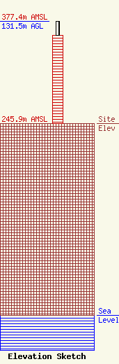
Site Elevation: 245.9 meters (807 ft) |
| Height of Structure: 113.3 meters (372 feet) |
| Overall Height Above Ground: 131.5 meters (431 feet) |
| Overall Height Above Mean Sea Level: 377.4 meters (1238 feet) |
| Owner Info | KENTUCKY AUTHORITY FOR EDUCATIONAL TELEVISION DBA WKAS
600 COOPER DR
LEXINGTON, KY 40502-2296
(859) 258-7000
SHOPKINS@KET.ORG |
| Contact Info | Kentucky Educational Authority
600 Cooper Drive
2587000
Lexington, KY 40502
Curtis Harper
(859) 258-7000
charper@ket.org |
