|
|
Antenna Structure Registration 1044169 |
 |
Registration Info | Registration Number: 1044169 |
| File Number: A1263718 |
| FAA Study: 2022-ASW-18887-OE |
| FAA Issue Date: 04/10/2023 |
| Status: Constructed |
| Date Constructed: 12/13/2023 |
| NEPA: N |
Structure Info
| Structure Type: GTOWER |
| Structure Coordinates: 33-53-24.0 N 98-33-31.5 W (NAD 83) |
| Structure Coordinates: 33-53-23.6 N 98-33-30.3 W (Converted to NAD 27) |
| Structure Address: 4500 Seymour Highway |
| Structure City: Wichita Falls, TX |
| Structure County: Wichita County |
| Painting & Lighting Info |
FAA Circular #: 70/7460-1M |
FAA Chapters: 3, 4, 5, 15 |
Remarks: PRIOR STUDY 1989-ASW-5-OE |
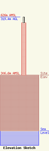
| Elevation Info |
Site Elevation: 306.6 meters (1006 ft) |
| Height of Structure: 287.2 meters (942 feet) |
| Overall Height Above Ground: 319.4 meters (1048 feet) |
| Overall Height Above Mean Sea Level: 626 meters (2054 feet) |
| Owner Info | Nexstar Media Inc.
545 E. John Carpenter Freeway
Irving, TX 75062
(972) 373-8800
jasroberts@nexstar.tv |
| Contact Info | Nexstar Media Inc.
545 E. John Carpenter Freeway
Irving, TX 75062
Jason Roberts
(972) 373-8800
jasroberts@nexstar.tv |
