|
|
Antenna Structure Registration 1044394 |
 |
Registration Info | Registration Number: 1044394 |
| File Number: A1262375 |
| FAA Study: 82-ASO-519-OE |
| FAA Issue Date: 03/05/1982 |
| Status: Constructed |
| Date Constructed: 10/01/1982 |
| NEPA: N |
Structure Info
| Structure Type: TOWER |
| Structure Coordinates: 36-27-59.0 N 88-56-47.0 W (NAD 83) |
| Structure Coordinates: 36-27-58.8 N 88-56-46.8 W (Converted to NAD 27) |
| Structure Address: 6535 Charles Bushart Rd |
| Structure City: South Fulton, TN |
| Structure County: Obion County |
| Painting & Lighting Info |
FCC Paragraph(s): 1, 3, 12, 21 |
Remarks: RED LIGHTS/PAINT |
| Elevation Info |
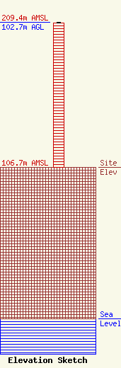
Site Elevation: 106.7 meters (350 ft) |
| Height of Structure: 101.9 meters (334 feet) |
| Overall Height Above Ground: 102.7 meters (337 feet) |
| Overall Height Above Mean Sea Level: 209.4 meters (687 feet) |
| Owner Info | Forever Communications, Inc.
351 Pascoe Blvd
Bowling Green, KY 42104
(270) 843-3333
chris@forevercom.com |
| Contact Info | Forever Communications, Inc.
351 Pascoe Blvd
Bowling Green, KY 42104
Christine Hillard
(270) 843-3333
chris@forevercom.com |
