|
|
Antenna Structure Registration 1044404 |
 |
Registration Info | Registration Number: 1044404 |
| File Number: A0185920 |
| FAA Study: 98-ASO-2373-OE |
| FAA Issue Date: 05/11/1998 |
| Status: Constructed |
| Date Constructed: 12/12/1995 |
| FAA EMI: N |
| NEPA: N |
Structure Info
| Structure Type: TOWER |
| Structure Coordinates: 37-43-18.0 N 86-2-10.0 W (NAD 83) |
| Structure Coordinates: 37-43-17.8 N 86-02-10.1 W (Converted to NAD 27) |
| Structure Address: 1199 Blueball Church Rd |
| Structure City: Elizabethtown, KY |
| Structure County: Hardin County |
| Painting & Lighting Info |
FAA Circular #: 70/7460-1J |
FAA Chapters: 4, 6, 13 |
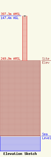
| Elevation Info |
Site Elevation: 249.9 meters (820 ft) |
| Height of Structure: 146.4 meters (480 feet) |
| Overall Height Above Ground: 147.4 meters (484 feet) |
| Overall Height Above Mean Sea Level: 397.3 meters (1303 feet) |
| Owner Info | SKYTOWER COMMUNICATIONS ETOWN INC
245 WEST DIXIE AVENUE
ELIZABETHTOWN, KY 42701
(270) 737-8000
bill@wqxe.com |
| Contact Info | SHOOK HARDY & BACON LLP
600 14TH STREET NW SUITE 800
WASHINGTON, DC 20005-2004
MARK LIPP
(202) 639-5606
mlipp@shb.com |
