|
|
Antenna Structure Registration 1044428 |
 |
Registration Info | Registration Number: 1044428 |
| File Number: A1367618 |
| FAA Study: 2005-AEA-2837-OE |
| FAA Issue Date: 09/01/2005 |
| Status: Constructed |
| Date Constructed: 01/01/1970 |
| FAA EMI: N |
| NEPA: N |
Structure Info
| Structure Type: TOWER |
| Structure Coordinates: 40-58-23.7 N 75-11-38.8 W (NAD 83) |
| Structure Coordinates: 40-58-23.4 N 75-11-40.2 W (Converted to NAD 27) |
| Structure Address: Godfrey Ridge Road |
| Structure City: Stroudsburg, PA |
| Structure County: Monroe County |
| Painting & Lighting Info |
FCC Paragraph(s): 1, 3, 11, 21 |
Remarks: Continue As Is OM&L = PAINT/RED LIGHTS |
| Elevation Info |
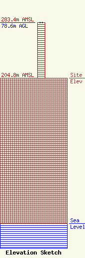
Site Elevation: 204.8 meters (672 ft) |
| Height of Structure: 78.3 meters (257 feet) |
| Overall Height Above Ground: 78.6 meters (258 feet) |
| Overall Height Above Mean Sea Level: 283.4 meters (930 feet) |
| Owner Info | Global Signal Acquisitions LLC
2000 Corporate Drive
Canonsburg, PA 15317
(724) 416-2400
Regulatory.Department@crowncastle.com |
| Contact Info | Crown Castle
2000 Corporate Drive
Canonsburg, PA 15317
Tom Anderson
(724) 743-6330
Tom.Anderson@crowncastle.com |
