|
|
Antenna Structure Registration 1044690 |
 |
Registration Info | Registration Number: 1044690 |
| File Number: A1332564 |
| FAA Study: 2024-ASO-23685-OE |
| FAA Issue Date: 01/29/2025 |
| Status: Constructed |
| Date Constructed: 01/01/1992 |
| NEPA: N |
Structure Info
| Structure Type: GTOWER |
| Structure Coordinates: 34-59-22.0 N 89-51-45.0 W (NAD 83) |
| Structure Coordinates: 34-59-21.7 N 89-51-44.7 W (Converted to NAD 27) |
| Structure Address: 8786 Old Craft Rd (273575) |
| Structure City: Mineral Wells, MS |
| Structure County: DeSoto County |
| Painting & Lighting Info |
FAA Circular #: 70/7460-1M |
FAA Chapters: 4, 8, 15 |
Remarks: PRIOR STUDY 2011-ASO-7686-OE |
| Elevation Info |
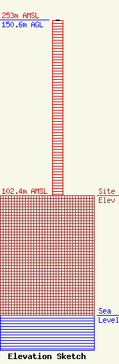
Site Elevation: 102.4 meters (336 ft) |
| Height of Structure: 149.7 meters (491 feet) |
| Overall Height Above Ground: 150.6 meters (494 feet) |
| Overall Height Above Mean Sea Level: 253 meters (830 feet) |
| Owner Info | American Towers LLC
10 Presidential Way
Woburn, MA 01801
(781) 926-4500
faa-fcc@americantower.com |
| Contact Info | American Towers LLC
10 Presidential Way
Woburn, MA 01801
(781) 926-4500
faa-fcc@americantower.com |
