|
|
Antenna Structure Registration 1044718 |
 |
Registration Info | Registration Number: 1044718 |
| File Number: A1319577 |
| FAA Study: 2025-AWP-3689-OE |
| FAA Issue Date: 05/07/2025 |
| Status: Constructed |
| Date Constructed: 02/25/1998 |
| NEPA: N |
Structure Info
| Structure Type: GTOWER |
| Structure Coordinates: 37-29-57.7 N 121-52-20.7 W (NAD 83) |
| Structure Coordinates: 37-29-57.9 N 121-52-16.9 W (Converted to NAD 27) |
| Structure Address: Mount Allison 3 Mi E 9526 Weller Rd (ca1899d-a) |
| Structure City: Fremont, CA |
| Structure County: Alameda County |
| Painting & Lighting Info |
FAA Circular #: 70/7460-1M |
FAA Chapters: 4, 8, 15 |
Remarks: PRIOR STUDY 2024-AWP-13707-OE |
| Elevation Info |
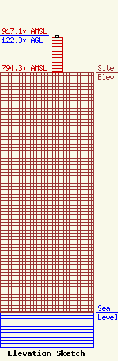
Site Elevation: 794.3 meters (2606 ft) |
| Height of Structure: 115.8 meters (380 feet) |
| Overall Height Above Ground: 122.8 meters (403 feet) |
| Overall Height Above Mean Sea Level: 917.1 meters (3009 feet) |
| Owner Info | SBA Towers XI, LLC
8051 Congress Avenue
Boca Raton, FL 33487
(561) 995-7670
ERoach@sbasite.com |
| Contact Info | SBA Towers XI, LLC
8051 Congress Avenue
Boca Raton, FL 33487
(561) 995-7670
ERoach@sbasite.com |
