|
|
Antenna Structure Registration 1044791 |
 |
Registration Info | Registration Number: 1044791 |
| File Number: A1348261 |
| FAA Study: 2015-AEA-844-OE |
| FAA Issue Date: 03/11/2015 |
| Status: Constructed |
| Date Constructed: 11/15/2015 |
| NEPA: N |
Structure Info
| Structure Type: GTOWER |
| Structure Coordinates: 39-25-53.6 N 75-20-12.0 W (NAD 83) |
| Structure Coordinates: 39-25-53.2 N 75-20-13.3 W (Converted to NAD 27) |
| Structure Address: 1.2 Mi Sw Of Roadstown Nj |
| Structure City: Canton, NJ |
| Structure County: Cumberland County |
| Painting & Lighting Info |
FCC Paragraph(s): 1, 3, 11, 21 |
Remarks: Continue As Is OM&L = PAINT/RED LIGHTS |
| Elevation Info |
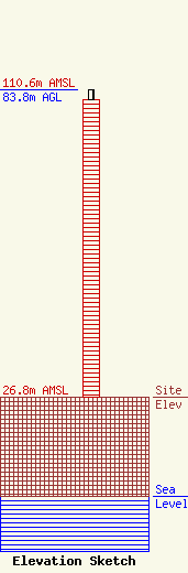
Site Elevation: 26.8 meters (88 ft) |
| Height of Structure: 81.1 meters (266 feet) |
| Overall Height Above Ground: 83.8 meters (275 feet) |
| Overall Height Above Mean Sea Level: 110.6 meters (363 feet) |
| Owner Info | WBOC, Inc.
1729 N. Salisbury Blvd.
Salisbury, MD 21801
(443) 880-9090
cjahelka@wboc.com |
| Contact Info | WBOC, Inc.
1729 N. Salisbury Blvd.
Salisbury, MD 21801
Craig Jahelka
(443) 880-9090
cjahelka@wboc.com |
