|
|
Antenna Structure Registration 1044818 |
 |
Registration Info | Registration Number: 1044818 |
| File Number: A0549945 |
| FAA Study: 2007-ASO-751-OE |
| FAA Issue Date: 03/13/2007 |
| Status: Constructed |
| Date Constructed: 05/17/2007 |
| FAA EMI: N |
| NEPA: N |
Structure Info
| Structure Type: TOWER |
| Structure Coordinates: 38-7-1.0 N 82-48-0.0 W (NAD 83) |
| Structure Coordinates: 38-07-00.7 N 82-48-00.4 W (Converted to NAD 27) |
| Structure Address: 2069 Adams Fork Road |
| Structure City: Louisa, KY |
| Structure County: Lawrence County |
| Painting & Lighting Info |
FAA Circular #: 70/7460-1K |
FAA Chapters: 3, 4, 5, 12 |
Remarks: Removed expiration date from determination. Scenario 1./jjs/case#635066 |
| Elevation Info |
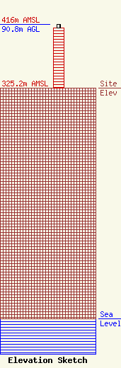
Site Elevation: 325.2 meters (1067 ft) |
| Height of Structure: 85.3 meters (280 feet) |
| Overall Height Above Ground: 90.8 meters (298 feet) |
| Overall Height Above Mean Sea Level: 416 meters (1365 feet) |
| Owner Info | KENTUCKY, COMMONWEALTH OF DBA = KY EMERGENCY WARNING SYSTEM KEWS
100 Minuteman Pky Building 101
Frankfort, KY 40601
(502) 564-5397
william.hays@ky.gov |
