|
|
Antenna Structure Registration 1044824 |
 |
Registration Info | Registration Number: 1044824 |
| File Number: A0547370 |
| FAA Study: 77-ASO-903-OE |
| FAA Issue Date: 05/17/1977 |
| Status: Constructed |
| Date Constructed: 11/20/1997 |
| FAA EMI: N |
| NEPA: N |
Structure Info
| Structure Type: TOWER |
| Structure Coordinates: 36-51-17.0 N 88-39-40.0 W (NAD 83) |
| Structure Coordinates: 36-51-16.8 N 88-39-39.8 W (Converted to NAD 27) |
| Structure Address: 2 Mi N On Us 45 |
| Structure City: Mayfield, KY |
| Structure County: Graves County |
| Painting & Lighting Info |
FCC Paragraph(s): 1, 3, 11, 21 |
Remarks: RED LIGHTS/PAINT |
| Elevation Info |
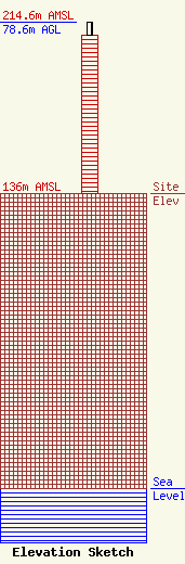
Site Elevation: 136 meters (446 ft) |
| Height of Structure: 73 meters (240 feet) |
| Overall Height Above Ground: 78.6 meters (258 feet) |
| Overall Height Above Mean Sea Level: 214.6 meters (704 feet) |
| Owner Info | KENTUCKY, COMMONWEALTH OF DBA = KY EMERGENCY WARNING SYSTEM KEWS
100 Minuteman PKY Building 101
Frankfort, KY 40601
(502) 564-5397
william.hays@ky.gov |
