|
|
Antenna Structure Registration 1044825 |
 |
Registration Info | Registration Number: 1044825 |
| File Number: A0549975 |
| FAA Study: 2007-ASO-487-OE |
| FAA Issue Date: 03/05/2007 |
| Status: Constructed |
| Date Constructed: 05/17/2007 |
| FAA EMI: N |
| NEPA: N |
Structure Info
| Structure Type: TOWER |
| Structure Coordinates: 37-5-4.0 N 87-4-17.0 W (NAD 83) |
| Structure Coordinates: 37-05-03.8 N 87-04-17.0 W (Converted to NAD 27) |
| Structure Address: 100 Malone Farm Lane |
| Structure City: Dunmore, KY |
| Structure County: Muhlenberg County |
| Painting & Lighting Info |
FCC Paragraph(s): 1, 3, 11, 21 |
Remarks: PRIOR STUDY 1979-ASO-2227-OE |
Remarks: Continue As Is OM&L = PAINT/RED LIGHTS |
| Elevation Info |
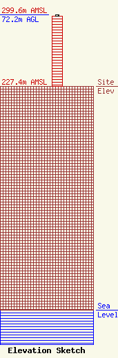
Site Elevation: 227.4 meters (746 ft) |
| Height of Structure: 71.3 meters (234 feet) |
| Overall Height Above Ground: 72.2 meters (237 feet) |
| Overall Height Above Mean Sea Level: 299.6 meters (983 feet) |
| Owner Info | KENTUCKY, COMMONWEALTH OF DBA = KY EMERGENCY WARNING SYSTEM KEWS
100 Minuteman Pky Building 101
Frankfort, KY 40601
(502) 564-5397
william.hays@ky.gov |
