|
|
Antenna Structure Registration 1044826 |
 |
Registration Info | Registration Number: 1044826 |
| File Number: A0547371 |
| FAA Study: 76-SO-1211-OE |
| FAA Issue Date: 07/26/1976 |
| Status: Constructed |
| Date Constructed: 06/14/1977 |
| FAA EMI: N |
| NEPA: N |
Structure Info
| Structure Type: TOWER |
| Structure Coordinates: 37-13-5.0 N 87-50-45.0 W (NAD 83) |
| Structure Coordinates: 37-13-04.8 N 87-50-45.0 W (Converted to NAD 27) |
| Structure Address: Needmore Fire Lookout Ky 293 |
| Structure City: Needmore, KY |
| Structure County: Caldwell County |
| Painting & Lighting Info |
FCC Paragraph(s): 1, 3, 11, 21 |
Remarks: RED LIGHTS/PAINT |
| Elevation Info |
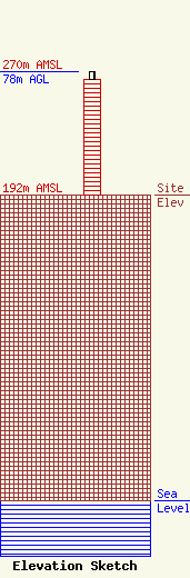
Site Elevation: 192 meters (630 ft) |
| Height of Structure: 73 meters (240 feet) |
| Overall Height Above Ground: 78 meters (256 feet) |
| Overall Height Above Mean Sea Level: 270 meters (886 feet) |
| Owner Info | KENTUCKY, COMMONWEALTH OF DBA = KY EMERGENCY WARNING SYSTEM KEWS
100 Minuteman PKY Building 101
Frankfort, KY 40601
(502) 564-5397
william.hays@ky.gov |
