|
|
Antenna Structure Registration 1044833 |
 |
Registration Info | Registration Number: 1044833 |
| File Number: A0547373 |
| FAA Study: 77-ASO-888-OE |
| FAA Issue Date: 04/28/1977 |
| Status: Constructed |
| Date Constructed: 06/01/1978 |
| FAA EMI: N |
| NEPA: N |
Structure Info
| Structure Type: TOWER |
| Structure Coordinates: 37-54-9.0 N 86-10-6.0 W (NAD 83) |
| Structure Coordinates: 37-54-08.8 N 86-10-06.1 W (Converted to NAD 27) |
| Structure Address: Ekron Lookout Tower |
| Structure City: Ekron, KY |
| Structure County: Meade County |
| Painting & Lighting Info |
FCC Paragraph(s): 1, 3, 11, 21 |
Remarks: RED LIGHTS/PAINT. |
| Elevation Info |
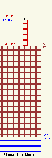
Site Elevation: 300 meters (984 ft) |
| Height of Structure: 85 meters (279 feet) |
| Overall Height Above Ground: 91 meters (299 feet) |
| Overall Height Above Mean Sea Level: 391 meters (1283 feet) |
| Owner Info | KENTUCKY, COMMONWEALTH OF DBA = KY EMERGENCY WARNING SYSTEM KEWS
100 Minuteman PKY Building 101
Frankfort, KY 40601
(502) 564-5397
william.hays@ky.gov |
