|
|
Antenna Structure Registration 1044842 |
 |
Registration Info | Registration Number: 1044842 |
| File Number: A0547377 |
| FAA Study: 77-ASO-896-OE |
| FAA Issue Date: 04/28/1977 |
| Status: Constructed |
| Date Constructed: 05/19/1978 |
| FAA EMI: N |
| NEPA: N |
Structure Info
| Structure Type: TOWER |
| Structure Coordinates: 37-44-44.0 N 84-54-50.0 W (NAD 83) |
| Structure Coordinates: 37-44-43.7 N 84-54-50.2 W (Converted to NAD 27) |
| Structure Address: Rose Hill |
| Structure City: Harrodsburg, KY |
| Structure County: Mercer County |
| Painting & Lighting Info |
FCC Paragraph(s): 1, 3, 11, 21 |
Remarks: RED LIGHTS/PAINT. |
| Elevation Info |
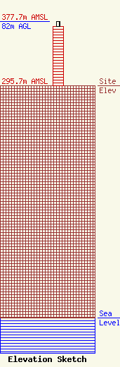
Site Elevation: 295.7 meters (970 ft) |
| Height of Structure: 76 meters (249 feet) |
| Overall Height Above Ground: 82 meters (269 feet) |
| Overall Height Above Mean Sea Level: 377.7 meters (1239 feet) |
| Owner Info | KENTUCKY, COMMONWEALTH OF DBA = KY EMERGENCY WARNING SYSTEM KEWS
100 Minuteman PKY Building 101
Frankfort, KY 40601
(502) 564-5397
william.hays@ky.gov |
