|
|
Antenna Structure Registration 1044843 |
 |
Registration Info | Registration Number: 1044843 |
| File Number: A0549956 |
| FAA Study: 2007-ASO-753-OE |
| FAA Issue Date: 03/21/2007 |
| Status: Constructed |
| Date Constructed: 05/17/2007 |
| FAA EMI: N |
| NEPA: N |
Structure Info
| Structure Type: TOWER |
| Structure Coordinates: 37-31-10.0 N 84-52-10.8 W (NAD 83) |
| Structure Coordinates: 37-31-09.7 N 84-52-11.0 W (Converted to NAD 27) |
| Structure Address: 841 Sand Knob Rd |
| Structure City: Liberty, KY |
| Structure County: Casey County |
| Painting & Lighting Info |
FAA Circular #: 70/7460-1K |
FAA Chapters: 3, 4, 5, 12 |
Remarks: PRIOR STUDY 1977-ASO-301-OE |
| Elevation Info |
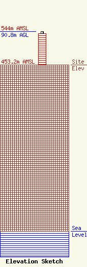
Site Elevation: 453.2 meters (1487 ft) |
| Height of Structure: 85.3 meters (280 feet) |
| Overall Height Above Ground: 90.8 meters (298 feet) |
| Overall Height Above Mean Sea Level: 544 meters (1785 feet) |
| Owner Info | KENTUCKY, COMMONWEALTH OF DBA = KY EMERGENCY WARNING SYSTEM KEWS
100 Minuteman Pky Building 101
Frankfort, KY 40601
(502) 564-5397
william.hays@ky.gov |
