|
|
Antenna Structure Registration 1044848 |
 |
Registration Info | Registration Number: 1044848 |
| File Number: A0549952 |
| FAA Study: 2007-ASO-1048-OE |
| FAA Issue Date: 03/28/2007 |
| Status: Constructed |
| Date Constructed: 05/17/2007 |
| FAA EMI: N |
| NEPA: N |
Structure Info
| Structure Type: TOWER |
| Structure Coordinates: 37-50-41.0 N 82-40-5.0 W (NAD 83) |
| Structure Coordinates: 37-50-40.7 N 82-40-05.4 W (Converted to NAD 27) |
| Structure Address: 12377 Ky Rt 40 East |
| Structure City: Boones Camp, KY |
| Structure County: Martin County |
| Painting & Lighting Info |
FCC Paragraph(s): 1, 3, 11, 21 |
Remarks: PRIOR STUDY 1978-ASO-74-OE |
Remarks: Continue As Is OM&L = PAINT/RED LIGHTS |
| Elevation Info |
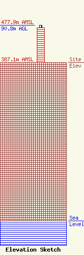
Site Elevation: 387.1 meters (1270 ft) |
| Height of Structure: 85.3 meters (280 feet) |
| Overall Height Above Ground: 90.8 meters (298 feet) |
| Overall Height Above Mean Sea Level: 477.9 meters (1568 feet) |
| Owner Info | KENTUCKY, COMMONWEALTH OF DBA = KY EMERGENCY WARNING SYSTEM KEWS
100 Minuteman Pky Building 101
Frankfort, KY 40601
(502) 564-5397
william.hays@ky.gov |
