|
|
Antenna Structure Registration 1044913 |
 |
Registration Info | Registration Number: 1044913 |
| File Number: A1206309 |
| FAA Study: 68-SEA-217-OE |
| FAA Issue Date: 11/19/1968 |
| Status: Constructed |
| Date Constructed: 12/06/1968 |
| FAA EMI: N |
| NEPA: N |
Structure Info
| Structure Type: TOWER |
| Structure Coordinates: 46-31-58.0 N 120-30-18.0 W (NAD 83) |
| Structure Coordinates: 46-31-58.5 N 120-30-13.8 W (Converted to NAD 27) |
| Structure Address: Ahtanum Ridge |
| Structure City: Yakima, WA |
| Structure County: Yakima County |
| Painting & Lighting Info |
FCC Paragraph(s): 1, 3, 11, 21 |
Remarks: RED LIGHTS/PAINT |
| Elevation Info |
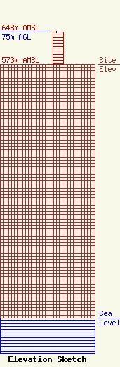
Site Elevation: 573 meters (1880 ft) |
| Height of Structure: 73.8 meters (242 feet) |
| Overall Height Above Ground: 75 meters (246 feet) |
| Overall Height Above Mean Sea Level: 648 meters (2126 feet) |
| Owner Info | Townsquare Media Yakima, LLC
1 Manhattanville Road
Purchase, NY 10577
(203) 861-0900
fcccontact@townsquaremedia.com |
| Contact Info | Townsquare Media Yakima, LLC
1 Manhattanville Road
Purchase, NY 10577
(203) 861-0900
fcccontact@townsquaremedia.com |
