|
|
Antenna Structure Registration 1045019 |
 |
Registration Info | Registration Number: 1045019 |
| File Number: A1102141 |
| FAA Study: 2011-ANE-1955-OE |
| FAA Issue Date: 12/27/2011 |
| Status: Constructed |
| Date Constructed: 01/01/1934 |
| FAA EMI: N |
| NEPA: N |
Structure Info
| Structure Type: 2TA1 |
| Structure Coordinates: 41-48-47.4 N 72-41-44.1 W (NAD 83) |
| Structure Coordinates: 41-48-47.0 N 72-41-45.8 W (Converted to NAD 27) |
| Structure Address: Twr 1 - 869 Blue Hills Ave |
| Structure City: Bloomfield, CT |
| Structure County: Hartford County |
| Painting & Lighting Info |
FCC Paragraph(s): 1, 3, 12, 21 |
Remarks: PRIOR STUDY 1998-ANE-307-OE. FAA approved FAA Chapters 3,4,5,12 70/7460-1K. Tower is using grandfathered lighting, FCC Paragraphs 1,3,12,21. |
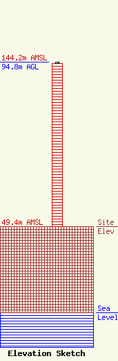
| Elevation Info |
Site Elevation: 49.4 meters (162 ft) |
| Height of Structure: 93.9 meters (308 feet) |
| Overall Height Above Ground: 94.8 meters (311 feet) |
| Overall Height Above Mean Sea Level: 144.2 meters (473 feet) |
| Owner Info | Red Wolf Broadcasting Corporation
758 Colonel Ledyard Highway
357
Ledyard, CT 06339
(860) 883-4292
jwjjf1180am@aol.com |
| Contact Info | Edinger Associates PLLC
1875 I Street, NW
Washington, DC 20006
Scott Woodworth
(202) 747-1694
swoodworth@edingerlaw.net |
