|
|
Antenna Structure Registration 1045081 |
 |
Registration Info | Registration Number: 1045081 |
| File Number: A1297395 |
| FAA Study: 92-ASW-0444-OE |
| FAA Issue Date: 07/17/1992 |
| Status: Constructed |
| Date Constructed: 01/19/1967 |
| FAA EMI: N |
| NEPA: N |
Structure Info
|
| Structure Coordinates: 27-40-22.0 N 99-39-52.0 W (NAD 83) |
| Structure Coordinates: 27-40-21.0 N 99-39-50.8 W (Converted to NAD 27) |
| Structure Address: 15 Mi Nnw From Laredo On Rt 1472 |
| Structure City: Webb County, TX |
| Structure County: Webb County |
| Painting & Lighting Info |
FCC Paragraph(s): 1, 3, 8, 17, 21 |
Remarks: RED LIGHTS/PAINT |
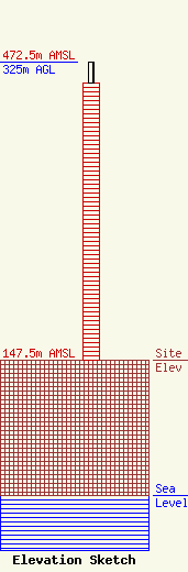
| Elevation Info |
Site Elevation: 147.5 meters (484 ft) |
| Height of Structure: 302 meters (991 feet) |
| Overall Height Above Ground: 325 meters (1066 feet) |
| Overall Height Above Mean Sea Level: 472.5 meters (1550 feet) |
| Owner Info | Gray Local Media, Inc.
4370 Peachtree Road, NE
Atlanta, GA 30319
(404) 266-8333
legalnotices@graymedia.com |
| Contact Info | Gray Local Media, Inc.
4370 Peachtree Road NE
Atlanta, GA 30319
Engineering Department
(404) 266-8333
legalnotices@graymedia.com |
