|
|
Antenna Structure Registration 1045118 |
 |
Registration Info | Registration Number: 1045118 |
| File Number: A0995174 |
| FAA Study: 2005-ASO-4513-OE |
| FAA Issue Date: 10/06/2005 |
| Status: Constructed |
| Date Constructed: 01/01/1975 |
| FAA EMI: N |
| NEPA: N |
Structure Info
| Structure Type: 2TA1 |
| Structure Coordinates: 33-37-2.2 N 80-46-50.7 W (NAD 83) |
| Structure Coordinates: 33-37-01.6 N 80-46-51.4 W (Converted to NAD 27) |
| Structure Address: 0.5 Mi E Of Sr-s-9-25, Between Us 601 And Shrike Road |
| Structure City: Saint Matthews, SC |
| Structure County: Calhoun County |
| Painting & Lighting Info |
FCC Paragraph(s): 1 |
Remarks: PRIOR STUDY 1976-ASO-1251-OE |
Remarks: Continue As Is OM&L = MARKED |
Remarks: Continue As Is OM&L = DUAL MEDIUM CATENARY |
Remarks: PRIOR STUDY 1976-ASO-1251-OE |
Remarks: Continue As Is OM&L = MARKED |
| Elevation Info |
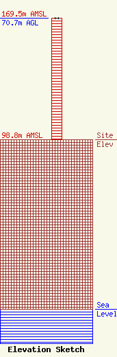
Site Elevation: 98.8 meters (324 ft) |
| Height of Structure: 70.7 meters (232 feet) |
| Overall Height Above Ground: 70.7 meters (232 feet) |
| Overall Height Above Mean Sea Level: 169.5 meters (556 feet) |
| Owner Info | Community Broadcasters, LLC
199 Wealtha Avenue
Watertown, NY 13601
(315) 782-1240
jim_leven@commbroadcasters.com |
| Contact Info | Fletcher, Heald & Hildreth, PLC
1300 North 17th Street
Arlington, VA 22209
Francisco Montero
(703) 812-0400
montero@fhhlaw.com |
