|
|
Antenna Structure Registration 1045123 |
 |
Registration Info | Registration Number: 1045123 |
| File Number: A1035044 |
| FAA Study: 74-EA-170-OE |
| FAA Issue Date: 03/20/1974 |
| Status: Constructed |
| Date Constructed: 01/01/1973 |
| NEPA: N |
Structure Info
|
| Structure Coordinates: 40-51-53.0 N 74-12-2.0 W (NAD 83) |
| Structure Coordinates: 40-51-52.6 N 74-12-03.5 W (Converted to NAD 27) |
| Structure Address: 42 Clove Rd |
| Structure City: Montclair, NJ |
| Structure County: Passaic County |
| Painting & Lighting Info |
FCC Paragraph(s): A1, B, C, H |
Remarks: HIGH INTENSITY WHITE LIGHTS |
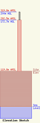
| Elevation Info |
Site Elevation: 119.8 meters (393 ft) |
| Height of Structure: 172.7 meters (567 feet) |
| Overall Height Above Ground: 200 meters (656 feet) |
| Overall Height Above Mean Sea Level: 319.8 meters (1049 feet) |
| Owner Info | NEW JERSEY PUBLIC BROADCASTING AUTHORITY
25 South Stockton St
777
Trenton, NJ 08608
(609) 777-5255
john.blair@treas.nj.gov |
| Contact Info | New Jersey Public Broadcasting Authority
25 South Stockton St
777
Trenton, NJ 08608
Richard Williams
(609) 203-6049
rick.williams@treas.nj.gov |
