|
|
Antenna Structure Registration 1045531 |
 |
Registration Info | Registration Number: 1045531 |
| File Number: A1272808 |
| FAA Study: 2022-ASW-23640-OE |
| FAA Issue Date: 04/10/2023 |
| Status: Constructed |
| Date Constructed: 09/19/2008 |
| NEPA: N |
Structure Info
| Structure Type: GTOWER |
| Structure Coordinates: 32-35-20.0 N 96-58-5.9 W (NAD 83) |
| Structure Coordinates: 32-35-19.5 N 96-58-04.9 W (Converted to NAD 27) |
| Structure Address: 1310 West Beltline Road (cowboy Tower/dallas #75256) |
| Structure City: Cedar Hill, TX |
| Structure County: Dallas County |
| Painting & Lighting Info |
FAA Circular #: 70/7460-1M |
FAA Chapters: 4, 9, 15 |
Remarks: PRIOR STUDY 2005-ASW-25-OE |
| Elevation Info |
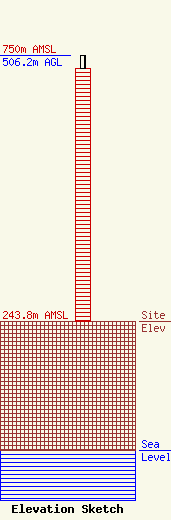
Site Elevation: 243.8 meters (800 ft) |
| Height of Structure: 480.7 meters (1577 feet) |
| Overall Height Above Ground: 506.2 meters (1661 feet) |
| Overall Height Above Mean Sea Level: 750 meters (2461 feet) |
| Owner Info | American Towers LLC
10 Presidential Way
Woburn, MA 01801
(781) 926-4500
faa-fcc@americantower.com |
| Contact Info | American Towers LLC
10 Presidential Way
Woburn, MA 01801
(781) 926-4500
faa-fcc@americantower.com |
