|
|
Antenna Structure Registration 1045877 |
 |
Registration Info | Registration Number: 1045877 |
| File Number: A1384047 |
| FAA Study: 2026-AEA-2768-OE |
| FAA Issue Date: 04/22/2026 |
| Status: Constructed |
| Date Constructed: 02/01/2013 |
| NEPA: N |
Structure Info
| Structure Type: LTOWER |
| Structure Coordinates: 40-28-37.0 N 74-29-31.5 W (NAD 83) |
| Structure Coordinates: 40-28-36.6 N 74-29-32.9 W (Converted to NAD 27) |
| Structure Address: 78 Veronica Ave (wheaton Nj #203688) |
| Structure City: Somerset, NJ |
| Structure County: Somerset County |
| Painting & Lighting Info |
FAA Circular #: 70/7460-1L |
FAA Chapters: 4, 8, 12 |
Remarks: OM&L to remain the same as prior studies = A MED-DUAL SYSTEM |
Remarks: PRIOR STUDIES 2010-AEA-2369-OE / 2017-AEA-13112-OE |
Remarks: OM&L to remain the same as prior studies = A MED-DUAL SYSTEM |
Remarks: PRIOR STUDIES 2010-AEA-2369-OE / 2017-AEA-13112-OE |
| Elevation Info |
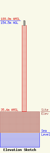
Site Elevation: 35.4 meters (116 ft) |
| Height of Structure: 146.5 meters (481 feet) |
| Overall Height Above Ground: 154.5 meters (507 feet) |
| Overall Height Above Mean Sea Level: 189.9 meters (623 feet) |
| Owner Info | American Towers LLC
10 Presidential Way
Woburn, MA 01801
(781) 926-4500
faa-fcc@americantower.com |
| Contact Info | American Towers LLC
10 Presidential Way
Woburn, MA 01801
(781) 926-4500
faa-fcc@americantower.com |
