|
|
Antenna Structure Registration 1045933 |
 |
Registration Info | Registration Number: 1045933 |
| File Number: A1342592 |
| FAA Study: 2016-ANE-12-OE |
| FAA Issue Date: 01/13/2016 |
| Status: Constructed |
| Date Constructed: 01/01/1996 |
| NEPA: N |
Structure Info
| Structure Type: GTOWER |
| Structure Coordinates: 41-29-36.7 N 73-25-43.9 W (NAD 83) |
| Structure Coordinates: 41-29-36.4 N 73-25-45.5 W (Converted to NAD 27) |
| Structure Address: 0.3 Mi. Sse Of Intersection Of Carmen Hill Rd & Se Trail |
| Structure City: Brookfield, CT |
| Structure County: Fairfield County |
| Painting & Lighting Info |
FAA Circular #: 70/7460-1L |
FAA Chapters: 4, 8, 12 |
Remarks: PRIOR STUDY 2009-ANE-1283-OE |
| Elevation Info |
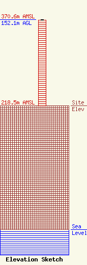
Site Elevation: 218.5 meters (717 ft) |
| Height of Structure: 151.2 meters (496 feet) |
| Overall Height Above Ground: 152.1 meters (499 feet) |
| Overall Height Above Mean Sea Level: 370.6 meters (1216 feet) |
| Owner Info | VB-S1 Assets, LLC
22 W Atlantic Avenue
Delray Beach, FL 33444
(561) 406-4015
fcc-faa@verticalbridge.com |
| Contact Info | VB-S1 Assets, LLC
22 W Atlantic Avenue
Delray Beach, FL 33444
Richard Hickey
(561) 406-4015
fcc-faa@verticalbridge.com |
