|
|
Antenna Structure Registration 1046244 |
 |
Registration Info | Registration Number: 1046244 |
| File Number: A1307463 |
| FAA Study: 2019-AGL-11540-OE |
| FAA Issue Date: 10/02/2019 |
| Status: Constructed |
| Date Constructed: 10/16/2019 |
| NEPA: N |
Structure Info
| Structure Type: GTOWER |
| Structure Coordinates: 47-20-32.0 N 97-17-21.0 W (NAD 83) |
| Structure Coordinates: 47-20-32.1 N 97-17-19.7 W (Converted to NAD 27) |
| Structure Address: 3 Miles West |
| Structure City: Blanchard, ND |
| Structure County: Traill County |
| Painting & Lighting Info |
FAA Circular #: 70/7460-1L |
FAA Chapters: 3, 4, 5, 12 |
Remarks: PRIOR STUDY 2018-AGL-15816-OE |
| Elevation Info |
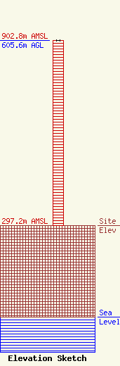
Site Elevation: 297.2 meters (975 ft) |
| Height of Structure: 605.6 meters (1987 feet) |
| Overall Height Above Ground: 605.6 meters (1987 feet) |
| Overall Height Above Mean Sea Level: 902.8 meters (2962 feet) |
| Owner Info | Gray Local Media, Inc.
4370 Peachtree Road, NE
Atlanta, GA 30319
(404) 266-8333
legalnotices@graymedia.com |
| Contact Info | Gray Local Media, Inc.
4370 Peachtree Road NE
Atlanta, GA 30319
(404) 266-8333
legalnotices@graymedia.com |
