|
|
Antenna Structure Registration 1046903 |
 |
Registration Info | Registration Number: 1046903 |
| File Number: A1385251 |
| FAA Study: 2026-ASO-7501-OE |
| FAA Issue Date: 04/27/2026 |
| Status: Constructed |
| Date Constructed: 01/01/1974 |
| NEPA: N |
Structure Info
| Structure Type: GTOWER |
| Structure Coordinates: 36-24-34.8 N 82-27-9.7 W (NAD 83) |
| Structure Coordinates: 36-24-34.4 N 82-27-10.2 W (Converted to NAD 27) |
| Structure Address: Gray Station Rd 7 Mi Nw Tn-5181 |
| Structure City: Johnson City, TN |
| Structure County: Washington County |
| Painting & Lighting Info |
FCC Paragraph(s): 3, 12, 21 |
Remarks: PRIOR STUDY 1998-ASO-2288-OE |
Remarks: Continue As Is OM&L = RED LIGHTS |
Remarks: PRIOR STUDY 1998-ASO-2288-OE |
Remarks: Continue As Is OM&L = RED LIGHTS |
| Elevation Info |
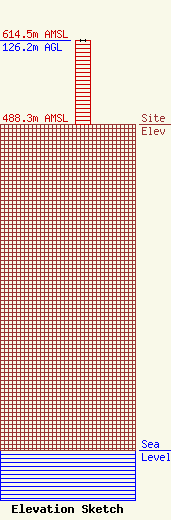
Site Elevation: 488.3 meters (1602 ft) |
| Height of Structure: 125.8 meters (413 feet) |
| Overall Height Above Ground: 126.2 meters (414 feet) |
| Overall Height Above Mean Sea Level: 614.5 meters (2016 feet) |
| Owner Info | VB Nimbus, LLC
22 W Atlantic Avenue
Delray Beach, FL 33444
(561) 406-4015
fcc-faa@verticalbridge.com |
| Contact Info | VB Nimbus, LLC
22 W Atlantic Avenue
Delray Beach, FL 33444
Richard Hickey
(561) 406-4015
fcc-faa@verticalbridge.com |
