|
|
Antenna Structure Registration 1046925 |
 |
Registration Info | Registration Number: 1046925 |
| File Number: A1041805 |
| FAA Study: 77-AEA-465-OE |
| FAA Issue Date: 06/27/1977 |
| Status: Constructed |
| Date Constructed: 01/01/1978 |
| NEPA: N |
Structure Info
|
| Structure Coordinates: 39-58-13.0 N 74-38-33.0 W (NAD 83) |
| Structure Coordinates: 39-58-12.6 N 74-38-34.4 W (Converted to NAD 27) |
| Structure Address: 628 County Route 530 |
| Structure City: Pemberton, NJ |
| Structure County: Burlington County |
| Painting & Lighting Info |
FAA Chapters: NONE |
| Elevation Info |
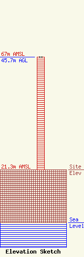
Site Elevation: 21.3 meters (70 ft) |
| Height of Structure: 45.7 meters (150 feet) |
| Overall Height Above Ground: 45.7 meters (150 feet) |
| Overall Height Above Mean Sea Level: 67 meters (220 feet) |
| Owner Info | BURLINGTON, COUNTY OF
1 Academy Drive
6000
Westampton, NJ 08060
(609) 518-7762
jkafka@co.burlington.nj.us |
| Contact Info | BURLINGTON, COUNTY OF
1 Academy Drive
6000
Westampton, NJ 08060
John Kafka
(609) 518-7762
jkafka@co.burlington.nj.us |
