|
|
Antenna Structure Registration 1047451 |
 |
Registration Info | Registration Number: 1047451 |
| File Number: A1205448 |
| FAA Study: 2020-AGL-21691-OE |
| FAA Issue Date: 11/05/2020 |
| Status: Constructed |
| Date Constructed: 11/09/2020 |
| NEPA: N |
Structure Info
| Structure Type: LTOWER |
| Structure Coordinates: 44-58-9.0 N 93-12-28.0 W (NAD 83) |
| Structure Coordinates: 44-58-09.1 N 93-12-27.2 W (Converted to NAD 27) |
| Structure Address: 3415 University Ave |
| Structure City: Minneapolis, MN |
| Structure County: Hennepin County |
| Painting & Lighting Info |
FAA Circular #: 70/7460-1L |
FAA Chapters: 4, 8, 12 |
| Elevation Info |
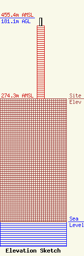
Site Elevation: 274.3 meters (900 ft) |
| Height of Structure: 162.7 meters (534 feet) |
| Overall Height Above Ground: 181.1 meters (594 feet) |
| Overall Height Above Mean Sea Level: 455.4 meters (1494 feet) |
| Owner Info | KSTP-TV, LLC
3415 UNIVERSITY AVENUE, WEST
ST. PAUL, MN 55114-2009
(651) 642-4334
RVandewiele@hbi.com |
| Contact Info | HUBBARD BROADCASTING, INC.
3415 UNIVERSITY AVENUE, WEST
ST. PAUL, MN 55114-2009
RYAN VANDEWIELE
(651) 642-4334
RVandewiele@hbi.com |
