|
|
Antenna Structure Registration 1047674 |
 |
Registration Info | Registration Number: 1047674 |
| File Number: A1159905 |
| FAA Study: 84-ASO-2433-OE |
| FAA Issue Date: 09/14/1984 |
| Status: Constructed |
| Date Constructed: 06/01/1986 |
| FAA EMI: N |
| NEPA: N |
Structure Info
| Structure Type: TOWER |
| Structure Coordinates: 34-50-21.0 N 82-31-36.0 W (NAD 83) |
| Structure Coordinates: 34-50-20.6 N 82-31-36.5 W (Converted to NAD 27) |
| Structure Address: 464 Kay Drive |
| Structure City: Easley, SC |
| Structure County: Pickens County |
| Painting & Lighting Info |
FCC Paragraph(s): 1, 3, 12, 21 |
Remarks: RED LIGHTS/PAINT |
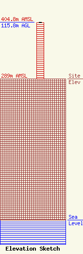
| Elevation Info |
Site Elevation: 289 meters (948 ft) |
| Height of Structure: 114.9 meters (377 feet) |
| Overall Height Above Ground: 115.8 meters (380 feet) |
| Overall Height Above Mean Sea Level: 404.8 meters (1328 feet) |
| Owner Info | Radio Training Network, Inc.
P.O. Box 7217
Lakeland, FL 33807
(863) 644-3464
gosrad@aol.com |
| Contact Info | Radio Training Network, Inc.
2420 Wade Hampton Blvd.
Greenville, SC 29615
Ted McCall
(864) 292-6040
Tedm@HisRadio.net |
