|
|
Antenna Structure Registration 1047704 |
 |
Registration Info | Registration Number: 1047704 |
| File Number: A0056124 |
| FAA Study: 97-ANM-1292-OE |
| FAA Issue Date: 10/24/1997 |
| Status: Constructed |
| Date Constructed: 01/01/1997 |
| NEPA: N |
Structure Info
| Structure Type: POLE |
| Structure Coordinates: 46-48-9.0 N 113-58-24.0 W (NAD 83) |
| Structure Coordinates: 46-48-09.3 N 113-58-20.6 W (Converted to NAD 27) |
| Structure Address: Atop Dean Stone Mountain |
| Structure City: Missoula, MT |
| Structure County: Missoula County |
| Painting & Lighting Info |
FAA Chapters: NONE |
Remarks: Removed expiration date from determination. Scenario 1./jjs/case#635066 |
| Elevation Info |
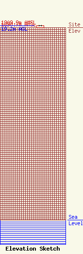
Site Elevation: 1890.7 meters (6203 ft) |
| Height of Structure: 19.2 meters (63 feet) |
| Overall Height Above Ground: 19.2 meters (63 feet) |
| Overall Height Above Mean Sea Level: 1909.9 meters (6266 feet) |
| Owner Info | HICKMAN SITES LLC
1314 N RUSSEL
MISSOULA, MT 59802
(406) 721-2255
|
