|
|
Antenna Structure Registration 1047781 |
 |
Registration Info | Registration Number: 1047781 |
| File Number: A1342601 |
| FAA Study: 98-ASO-0333-OE |
| FAA Issue Date: 02/19/1998 |
| Status: Constructed |
| Date Constructed: 09/06/2007 |
| FAA EMI: N |
| NEPA: N |
Structure Info
| Structure Type: 4TA3 |
| Structure Coordinates: 39-3-57.0 N 84-36-30.0 W (NAD 83) |
| Structure Coordinates: 39-03-56.8 N 84-36-30.2 W (Converted to NAD 27) |
| Structure Address: Twr 3 - 1100 Radio Road |
| Structure City: Villa Hills, KY |
| Structure County: Kenton County |
| Painting & Lighting Info |
FAA Circular #: 70/7460-1J |
FAA Chapters: 3, 4, 5, 13 |
| Elevation Info |
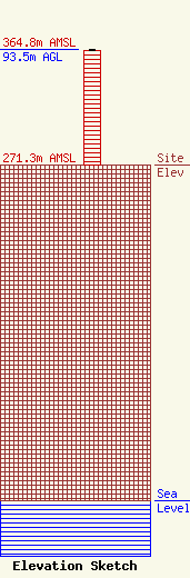
Site Elevation: 271.3 meters (890 ft) |
| Height of Structure: 92.9 meters (305 feet) |
| Overall Height Above Ground: 93.5 meters (307 feet) |
| Overall Height Above Mean Sea Level: 364.8 meters (1197 feet) |
| Owner Info | VB-S1 Assets, LLC
22 W Atlantic Avenue
Delray Beach, FL 33444
(561) 406-4015
fcc-faa@verticalbridge.com |
| Contact Info | VB-S1 Assets, LLC
22 W Atlantic Avenue
Delray Beach, FL 33444
Richard Hickey
(561) 406-4015
fcc-faa@verticalbridge.com |
